
Your Travel Companion in Cape Town
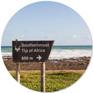
THE END OF AFRICA
Come with me, let’s take a drive to the end of my World.
We will leave the city centre and drive around the mountain, past the University and the President’s house at Groote Schuur, and through one of the old suburbs of Newlands. We will climb Wynberg hill which, as the name suggests, was once a vineyard on a small mountain. It was also a neighbourhood where, in Victorian times, individuals and families would rest for several months on their way back from their duties in the hot and debilitating environment of colonial India, jewel of the Imperial Empire. To help these often weary travellers Wynberg was made to appear very much like a timeless old English Village, with small, whitewashed, thatched cottages.
We come down from Wynberg hill into the lush, green Constantia valley, ringed on one side by mountains separating it from the Atlantic Ocean. It was here in the late 1600’s that one of the more unusual Governors of the Cape, Simon van der Stel, established South Africa’s first wine estate, Groot Constantia.
In the time of apartheid van der Stel would not have been allowed to live in Constantia or to own a wine estate because he was not a white man. His mother was of Indian descent and his father was the Governor of Mauritius, a white Dutchman. In fact van der Stel was born on a ship bound for Mauritius from the Far East. This fact of Simon van der Stel’s racial background was, of course, not revealed during the time of apartheid. A brilliant and remorselessly energetic man who among other achievements founded the town of Stellenbosch was not ‘one of us’.
As we drive through the Constantia Valley we see ahead a wall of mountains dividing the city of Cape Town into the area around the Table Mountain and the Peninsular. This wall is known as Silvermine, a nice romantic name but inaccurate. The earliest settlers were convinced that Silver would be found in this high, rocky area and dug holes to prove it, but found no precious metal apart from a little Manganese. Nevertheless it was a nice name and so Silvermine it remains..
If we turn sharply left we can drive around Silvermine and, following the side of the mountains we will find a vast, normally blue bay; False Bay as it is called. Another strange name which, according to the best known story, was given that name when foreign sailing ships seeking the new Dutch settlement and fresh provisions would sail around the Bay for days before realising their mistake and eventually find the Bay under Table Mountain, where the Dutch were waiting to do business.
The side of False Bay which we are following towards Cape Point was once dotted with several villages, each with their own character and history. We will return to their stories another day. These villages still exist and are distinct but are also part of the remarkable city of Cape Town.
We will encounter, just beyond Simon’s Town, a group of Cape Town’s most interesting inhabitants; the African Penguin colony at Boulders Beach. Why this short stretch of coastline is home to one or two thousand penguins is a mystery. They migrated to the area during the early 1980’s, apparently from a West Coast island habitat a couple of hours North of the city. It’s assumed that a decline in stocks of fish and probably the threat of predators (seals and sharks) drove them to their current location but, sadly, they don’t give interviews.
After enjoying a visit to our pretty black and white friends we will continue due South into the Cape of Good Hope Reserve and approach the end of our journey.
In the 15th Century the most precious of commodities, worth more than gold, were spices and these spices were found in the islands at the far Eastern end of the Indian Ocean. The spices made their way to Europe by sea and land, through many different border crossings, each pushing the prices higher.
At that time the two great seafaring nations were Spain and Portugal, who by treaty had divided the world into areas of influence and control. Portugal had the rights to the Indian Ocean, if they could find a way to get there. The question was simply, how far did the African continent extend and was it possible to get around Africa into the Indian Ocean?
A sea captain called Barthlomew Diaz was exploring the Atlantic coast and was caught in a great storm and driven far to the South. When the storm subsided he turned back to the North and landed on the Southern coast of Africa at Mossel Bay. He and his crew realised they had accidentally sailed into the Indian Ocean! Working their way back along the coast they found a Cape at the end of Africa and realised that this was the gateway to the riches of the Indian Ocean spice trade. Returning to Portugal, to be greeted by the King they were asked what they had named this Cape on their charts.
‘A very dangerous place, your Highness. It is the Cape of Storms’.
The king was not amused. If the gateway to the Indian Ocean was so dangerous sailors would be reluctant to make the long and terrible voyage and Portugal needed riches to match the gold and silver being brought by the Spanish ships from their half of the World.
It was agreed that the Cape of Storms needed a new and more ‘upbeat’ name to honour of its importance and encourage the sailors to risk the long, long journey
And so it became Cabo da Boa Esperança, the Cape of Good Hope!
Get a front-row seat to John’s storytelling journey. Sign up now to get sneak peeks of upcoming chapters. And be the first to know when Tales from the Driver’s Seat goes to print.
Copyright © 2026 Kestrel Services
Copyright © 2026 Kestrel Services